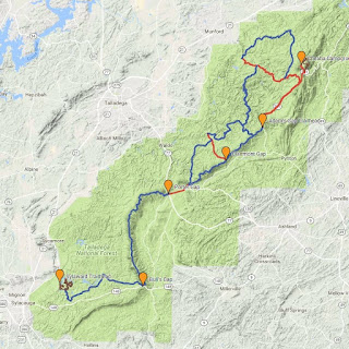
brown line = singletrack | blue line = dirt/gravel forest service road | red line = paved road
Be aware that none of these routes are marked. It is your responsibility to research the routes before you ride and prepare accordingly. These routes are meant for experienced riders who are self sufficient and proficient at GPS and map reading skills. Though it's generally a given with a group like this that anyone who can help someone in need will do so, this is technically an unsupported ride. It is your responsibility to carry everything you need to complete the route.
One-Way Options. The following one-way options are popular. If you're riding one way, it's up to you or your group to arrange for shuttle transportation at the beginning of the ride or the end of the ride. Ideally, the number of southbound riders will be roughly the same as the number of northbound riders. This has worked great in the past. On the Saturday morning of the ride, roughly half of the riders load up their bikes, drive to Sylaward, park and then ride back to Cheaha. The other half leave camp on their bikes and ride to Sylaward, where they load up their bikes in the vehicles left behind and return to camp. Arrangements are made for exchanges of keys beforehand. The shortest route Low Point Shuttle Run's pick-up point is 637 Creek Bridge.
- Low Point Shuttle Run | 22 miles and 1,300 ft | Strava | MapMyRide | ridewithgps
- Cheaha to Sylaward short | 46 miles and 4,000 ft | Strava | MapMyRide | ridewithgps
- Cheaha to Sylaward long | 56 miles and 5,200 ft | Strava | MapMyRide | ridewithgps
- Sylaward to Cheaha short | 46 miles and 5,800 ft | Strava | MapMyRide | ridewithgps
- Sylaward to Cheaha long | 56 miles and 7,000 ft | Strava | MapMyRide | ridewithgps
Loops and Out & Backs.. Don't worry about shuttle logistics. Start and end at the campground or just down the road at Adam's Gap where the gravel roads begin.
- Adam's Gap to Clairmont Gap out and back | 10 miles and 1,100 ft | Strava | MapMyRide | ridewithgps
- Adam's Gap/637/Skyway Fun Loop | 17 miles and 2,500 ft | Strava | MapMyRide | ridewithgps
- Adam's Gap/637/Union T/Skyway Fun Loop | 25 miles and 3,300 ft | Strava | MapMyRide | ridewithgps
- Cheaha/Kentuck/637 Loop | 38 miles and 4,900 ft | Strava | MapMyRide | ridewithgps
- Adam's Gap to Bull's Gap Out and Back | 52 miles and 5,200 ft | Strava | MapMyRide | ridewithgps
- Cheaha/Kentuck/637/Skyway Loop | 57 miles and 7,000 ft | Strava | MapMyRide | ridewithgps
- Adam's Gap to Sylaward Out and Back | 76 miles and 7,600 ft | Strava | MapMyRide | ridewithgps
- Cheaha to Sylaward and Back Century | 102 miles and 11,000 ft | Strava | MapMyRide | ridewithgps
